The first summer wave of anomalous sea temperature experienced last week is now over. The web and mobile app (https://app.stream-srf.com/auth/welcome/) developed in the STREAM project, led by Prof. Aldo Drago at MCAST’s Institute of Engineering and Transport (IET) with the support of Ing. David Debono from the Institute of ICT provided precise data coverage and monitored the event in detail. STREAM (www.stream-srf.com) is coordinated by MCAST in partnership with MST AudioVisual Ltd and THINK Design Ltd, and supported by the Space Research Fund of Xjenza Malta (ex MCST).

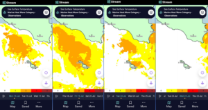
Pic1: Time evolution of the first Summer marine heat wave in the Maltese Islands showing intensity and geographical extent on a daily basis until it fades away.
Like other parameters at sea, the temperature at a single point is definitely not representative of the overall sea temperature, especially in an extended area such as that stretching over the sea surrounding 360o the Maltese Islands. At any instant, the thermal map of the sea presents a highly spatially variable picture composed of intertwining patterns of mixing warmer and cooler water bodies with temperature gradients and changes at different locations along the Malta/Gozo coast reaching even 4 oC at times. Moreover, the air-sea thermal energy flux is a two-way dynamical exchange, with the sea receiving a net gain of heat energy during daytime, and a net loss at night. The sea surface temperature (SST) is hence strongly influenced by the time of the day; highest values are reached in the early afternoon while lowest values are experienced in the early morning, with SST excursions of a few degrees Celcius characterising this daily cycle.

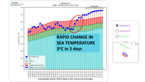
Pic 2: Onset of rapidly increasing Sea Surface Temperature near the Maltese Islands monitored by STREAM during the Marine Heat Wave.
Highly stable sensors on ESA (European Space Agency) satellite platforms like Sentinel 3 provide precise data for marine, land and atmospheric monitoring as well as for climate studies. SST sensing is the most emblematic application. The STREAM project has specialised in satellite data services that bring information to the citizen, provide support to local responsible entities, and channel data for users to exploit in many different applications. STREAM enables data to be channelled to users in a personalised manner, through a user-friendly mobile interface, and without the hassle of linking to complicated data retrievals from specialised databases. Just a few clicks and the data is available where and when it is needed.

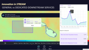
Pic 3: snapshot from the STREAM app showing its functionality to enable user-selected areas of interest for data elaboration and download.
The STREAM Marine Heat Wave service provided complete coverage of the anomalous sea temperature event that occurred in the area of Sicily and the Maltese Islands last week. The graphic shows how the geographical extent and intensity of the temperature at the surface of the sea varied from one day to another. Besides the maps, the STREAM app enables users to check values pixel by pixel, enabling user-selected data downloads for further elaboration and assessment.
The white color shows where the temperature remained close to normal, while the yellow and orange show where the sea was the warmest. The warm sea wave reached its highest peak on Saturday 20 July, but started to subside in the following days as the wind strength increased and mixed the warm surface water with the underlying deeper cooler layers of the sea. The phenomenon faded completely away by early this week. This will not be the last marine heat wave, and a new event is expected starting from next weekend. This time you know that you can follow it on the MCAST STREAM app (https://app.stream-srf.com/auth/welcome).


 MCAST Main Campus
  +356 2398 7100
 information@mcast.edu.mt