We cannot study and assess the marine environment without the support of data especially in cases of extreme phenomena like that of the record low sea levels experienced recently along the whole coast of the Maltese Islands. Availing of sea level data measured by Transport Malta at Marsaxlokk (courtesy Capt. Mark Chapelle, Head of the Hydrographic Office), Prof. Aldo Drago, now carrying out research within the Institute of Engineering and Transport at MCAST, puts paid to all suppositions and ambiguous explanations that appeared on public media in the last days, and relates the correct scientific explanation with details on the evolution of this formidable phenomenon that pushed the waterline out, uncovering large stretches of coast and marine habitats that usually lie covered and protected by the sea.
A lot has been said about how the sea dried up, where all this water went, and whether it would come back. Some had a feeling of premonition to some incumbent hazard such as from earthquakes or tsunami, or even some irreversible climatic change. But none of this! The earthquakes that hav recently hit Turkey and Syria have nothing to do with it, and there is no danger associated with what we have experienced. Understandably, those who study the sea variability can reassure that this is nothing but a regular phenomenon that happens every year, a natural cycle, that was however much stronger than usual, and hence drawing more attention and curiosity by the public.
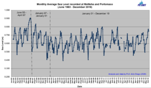
Figure 1: Evolution of mean monthly sea levels for the Maltese Islands (1993 – 2019)
Annual changes of the sea level are normal, with the average sea level reaching the highest in autumn. These sea levels are maintained until the following January when the sea level begins to gradually decline until it reaches its lowest in February or the beginning of March. The plot in Figure 1 shows some unpublished information on how the monthly mean sea level varied over a range of 25 years, and clearly shows how the sea level around the Maltese Islands, like in many other places in the Mediterranean Sea, regularly repeats this annual cycle although the range of the variability changes significantly from year to year.
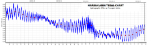
Figure 2: Sea level observations (blue) in Marsaxlokk Harbour (19th January – 24th February 2023) Red dots indicate the daily mean sea level. Courtesy of Capt. Mark Chapelle, Hydrographic Office, Transport Malta (Sea levels are measured with respect to the reference zero of the gauge).
The data time series of sea level measurements in Figure 2 enables us to do a more detailed analysis and better understand what happened at the local level. It shows hourly data over 37 days (in blue) starting from 19th January when the sea level was still high. The evident oscillations, twice daily, are caused by the tide. The higher frequency variations refer to the seiches which were not really influent in this period except during the storm episodes triggered by the cyclone Helios on 9th and 10th February. The daily mean sea level (in red) is the average of the observations each day, showing high levels until mid-January (with a maximum mean sea level of 0.78 m on 21st January), but experiencing a hefty downward non-monotonic trend in the subsequent days, dipping down by mid-February to 0.50 m below the average January levels (with a minimum mean sea level of 0.28m on 19th February). In comparison to previous years on record, this sea level decline is by far the highest annual variation of sea level ever measured; but nothing alarming, the sea level already started to rise back, and will gradually continue to do so during Summer, repeating the annual cycle. This analysis applies for the whole coastal extent around the Maltese Islands.
Other interesting features can be deducted from Figure 2. During Helios the associated cyclonic low atmospheric pressure triggered an inverse barometric effect with a temporary rise in sea level. The data also show how the superposition of the tide heightened the maximum sea levels to 0.98 m on 21st January during high tide, while it accentuated the low sea levels down to 0.09 m on the evening of 18th February when the sea was at its absolute minimum, a really exceptional low.
The annual cycle is completely natural and caused by the marine dynamics and air-sea exchanges at the Mediterranean scale; it is linked to increased sea water density (mainly due to a thermosteric effect of cooler and saltier water) which leads to water mass contraction; there is also the effect of the heat energy budget of the sea, and of the Mediterranean Sea freshwater budget with losses caused by evaporation and gains with precipitation and river flows from the ground; furthermore there is the effect of changes in the water flux exchanges with the Atlantic Ocean at the Strait of Gibraltar. This year this annual cycle also coincided with a sustained high atmospheric pressure in the third week of February which continued to suppress the water levels down (one centimeter down for each millibar increase in pressure). In addition, on 19th February, the Earth, the Moon and the Sun reached a position with a common axis that brings about a stronger gravitational attraction and hence a stronger tide. Indeed a number of complementary factors that led to this protruded extreme low sea level phenomenon.
These kind of extremes can also be indicators of climatic changes and should be studied more extensively. In fact, in addition to all these variations, sea level is also responding to an average long term annual increase in sea level (1 cm rise each year on average) measured over a number of years, which means that sea observations must be consistent and conducted in different places.
Phenomena of this type have an effect on the marine habitats, flora and organisms that live in the sea, especially those that are tied to the bottom, cannot move, become exposed and dry up when the water level goes down. With the absence of water that usually covers them, the heat of the sun puts stress on these organisms, causing bleaching and devastating damage especially when the exposure is extended in time.
Despite the importance of sea level data, their measurement does not yet form part of any long term, sustained and integrated national system of marine observations. Such observations are essential to provide the data that we need to measure and monitor our marine environment regularly and in real time.


 MCAST Main Campus
  +356 2398 7100
 information@mcast.edu.mt