The evolution of extremes in the atmosphere and the sea is not simply a monitoring or research exercise. Satellites offer a constant eye on the earth and its oceans by observing essential parameters as they change. In conjunction with numerical models, we can forecast changes with increasing accuracy, anticipating information on expected anomalous events before they happen, and hence aiding us to prepare for them, and be ready to respond well ahead.
The high sea surface temperature being experienced in these days is an example. MCAST researchers, led by Prof. Aldo Drago (Institute of Engineering and Transport) who conducts the STREAM project, had forecasted these anomalous sea temperatures already a week ago. Supported by Dr. David Debono (Institute of Information and Communications Technology), two local SMEs (MST AudioVisual Ltd and THINK Ltd) and DELTARES (a Dutch company dealing with the marine environment), the STREAM project, funded by the Malta Council for Science and Technology, has the main objective of bringing the data collected from satellites closer to partners in research, for exploitation by commercial enterprises, and to society in general. Serving as an intermediary, it is preparing a free service to make satellite data more accessible to common unexperienced users, including students, through a mobile app that will be used to deliver data on demand when and where it is needed.
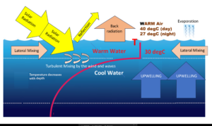
Water has many anomalous properties, one of which is its higher capacity to absorb and retain heat compared to other liquids. It takes a lot of heat energy to raise its temperature, but it then continues to retain it much longer before cooling. If we just consider a strip of water 20 km wide all around the Maltese Islands, it would require around 400 billion kWhours of energy to heat the top 10m by 8 degC. That is a phenomenal amount of energy; it is the equivalent of the local electricity production for ten years for every 1/2 a degree rise in temperature. The sun can provide all this energy. The warm water is lighter and remains trapped in the top upper layer of the sea, floating on top of the cooler water below it unless there is wind and waves to percolate it down the water column by turbulent mixing.

Schematic showing the physical factors that control the sea surface temperature (tides and sea level effects are excluded)
The persisting warm air on top of it acts like a cover, disallowing this warm water from losing enough heat energy during the night (mainly by back radiation) to keep the balance with that acquired during the day. The water continues to accumulate heat day after day with a subsequent increase in its temperature. Cooler currents, like the strong eastbound stream between Malta and Sicily (the Atlantic Ionian Stream, AIS), can bring lateral mixing and partially attenuate this increase. Upwelling phenomena such as those that we experience south of Gozo can trigger the rise of cooler water from the deeper sea layers, mixing with the upper warmer water as it rises vertically.
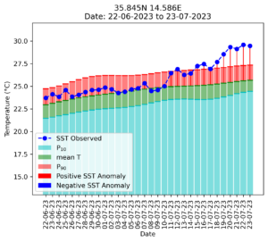
When all these factors compound together and act in favour to a particular scenario, then we get extremes. In the last week, the extraordinary high air temperatures were scorching during the day and further remained substantially on the high during the night, putting a barrier to heat energy flow from the sea back to the atmosphere; the wind was too low to put dynamics into the sea or to trigger upwelling; the AIS was not reaching the Maltese Islands and coastal waters remained isolated. By further considering the normal daily variations during the day (typically of the order of 1 oC), this led to sea surface temperatures, especially on the East coast of Malta, soaring above 30 oC for most of the day on Friday 21st and Saturday 22nd July; this year the phenomenon was even more extraordinary not only in intensity, but also in duration. On Sunday 23rd and Monday 23rd July the sea surface temperature remained above 30 oC throughout the whole days, reaching daily maxima close to 31oC.

30 days of SST anomalies at an offshore location East of Malta.(from daily satellite data at midnight, elaborated in STREAM). NB This does not include the diurnal heating which are about 1 DegC higher than midnight values).
Luckily the wind is coming to our rescue from late Tuesday 25th July onwards, mixing the warm water with the underlying cool water, and lowering the sea surface temperature to 28.5 oC by Thursday 27th July.
The main impact on marine creatures is on the fish in fishfarms because these fish are closed in cages and cannot go to look for colder water. The same happens for those organisms attached to the bottom of the sea. A higher sea temperature means a faster metabolic rate and then the fish consume more oxygen, while the dissolved oxygen in the water is less when the water is warmer.Changes in temperature can also have profound effects on a longer time span. Reproduction in fish depends on the seasonal changes in sea temperature. An anticipated increase in sea temperature in Spring can negate the reproductive development in the species that spawn in the Spring, while a delay in cooler sea temperature in Autumn disturbs the initiation of the reproductive cycle in those species that spawn in the Autumn. Therefore elevated temperatures can put a brake on fish reproduction in early Spring, and delay the start of reproduction in Autumn
Naturally, people are making questions and many of these do not concern physics, and cannot be plainly answered. The predicament is worrying if our seas and oceans keep warming up. What are we doing to our planet? The recent power cuts help us reflect. We focus too much on our comfort disregarding the impact this has on our planet and the delicate and perfect balance of nature as created by God. Yet we intervene, not to complete creation, but to disrupt it.


 MCAST Main Campus
  +356 2398 7100
 information@mcast.edu.mt